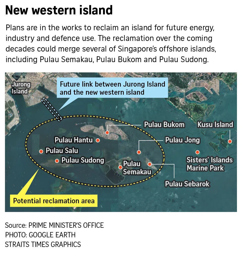
Stand on the southern tip of Tuas on a clear morning and you will see what Singapore's planners see: a horizon of tankers, cranes, and low green islets scattered across the Strait of Singapore. Beyond the petrochemical towers of Jurong Island, beyond the live-firing zones and the landfill that will eventually run out of space, there is still water — and in Singapore, water has always been the raw material of land.
The conversation stirring around western islands development in 2026 is quietly becoming one of the most consequential long-range property questions in the country. Reports and planning chatter have again put the spotlight on Lee's Point and a cluster of western islets, with speculative talk of fresh reclamation and, more provocatively, industrial-to-residential conversion. Could HDB towns and private condos one day rise where refineries, naval assets, and military training grounds now sit? For anyone under 40 who thinks the map of Singapore is fixed, the honest answer is: the map has never been fixed.
This is a story about what happens when a small island nation runs out of room, and why the next big growth zone might be built on the seabed.
Why Singapore Keeps Looking at the Sea
To understand the western islands buzz, you have to understand a national habit. Singapore has been making land from the sea for more than half a century, and it has never stopped.
At independence in 1965, the country covered roughly 581 square kilometres. By 2023, that figure had grown to about 734 square kilometres — an increase of more than 150 square kilometres, or roughly a quarter of today's total land area, all of it reclaimed. That is not a marginal footnote to the property story; it is the story itself.
Singapore's Land Area, 1965–2023 (sq km)
Every major milestone in modern Singapore property sits on reclaimed ground:
- Marina Bay and the CBD fringe — the financial district's waterfront skyline is built on land that was open sea in the 1970s.
- Changi Airport — Terminal 1 and the runways that followed were largely reclaimed from the sea.
- Jurong Island — once seven separate islets, now a single 3,200-hectare petrochemical powerhouse, merged through reclamation beginning in the 1990s.
- Semakau Landfill — Singapore's only landfill, opened in 1999, was created by enclosing the waters between Pulau Semakau and Pulau Sakeng.
- Tuas — the district now hosting the next-generation mega-port is itself a product of decades of filling and consolidation.
The pattern is consistent. When the mainland is exhausted, Singapore builds sideways into the sea. The islets west of Jurong Island — Pulau Sudong, Pulau Pawai, Pulau Ular, Pulau Senang, and the unnamed rocks and shoals around them — are among the few remaining places where that sideways expansion could still happen at scale.
But there is a difference this time. Past reclamation was driven by the needs of ports, airports, industry, and the military. The new conversation, bubbling through planning circles in 2026, is about homes.
Lee's Point and the Western Islets: What's Actually on the Table
Let's be precise about what is confirmed and what is not.
No western island development has been gazetted. The URA Master Plan 2025, released recently, was overwhelmingly about densifying existing towns, adding BTO sites on the mainland, and reimagining areas like the Greater Southern Waterfront. The western islets do not appear in it as a housing destination.
What has happened is more interesting: a revival of long-range planning interest. The name that keeps surfacing in conversation is Lee's Point, a stretch of headland and shallow shoal off the southwest coast, west of Jurong Island and the Tuas port complex. According to reports and planning chatter, it has been floated in exploratory discussions as a potential footprint for future reclamation — the kind of site that would be studied, costed, and probably redesigned several times before anything is announced.
To understand the geography, here is what currently sits on and around the western islets:
| Site | Current Use | Reclamation Status |
|---|---|---|
| Jurong Island | Petrochemical hub, ~3,200 ha | Fully amalgamated from 7 islets |
| Pulau Semakau | Landfill (expected to last until ~2040), biodiversity | Reclaimed enclosure |
| Pulau Sudong, Pulau Pawai, Pulau Ular | Military live-firing and training areas | Mostly natural |
| Pulau Senang | Former penal settlement site, now largely unused | Natural |
| Tuas / Lee's Point vicinity | Port, industrial estates, future Tuas Port phases | Partially reclaimed |
The islands themselves are not empty wilderness — much of the southwest is restricted military terrain, which makes any development a multi-decade, multi-agency exercise. But that is precisely the point: when the armed forces eventually consolidate or relocate training areas (a process that has happened repeatedly in Singapore's history), the land doesn't stay idle for long.
Why Now? Three Forces Converging
Three separate pressures have pushed the western islets back into the frame as 2026 begins.
First, the Tuas Port transition. The Tuas mega-port, being built on reclaimed land, is slated to consolidate all of Singapore's container operations by the 2040s, with a projected capacity of 65 million twenty-foot equivalent units (TEUs) a year. Under current plans, the older terminals at Tanjong Pagar have already wound down, and the Keppel and Brani terminals are expected to follow by the end of the decade. As heavy port operations migrate west, the coastline they vacate — and the coastline beyond them — becomes available for rethinking. The momentum of all that marine engineering has a spillover effect: the dredgers and piling equipment are already in the western waters.
Second, sea-level rise has made coastal protection a national priority. In 2019, then-Prime Minister Lee Hsien Loong said at the National Day Rally that Singapore could spend $100 billion or more over 50 to 100 years to defend its coastline. That figure reframed reclamation from a nice-to-have into a strategic necessity. If you are going to build sea walls and elevated land anyway, the marginal cost of making that land usable for housing drops. Coastal defence and new land become two sides of the same engineering budget.
Third, the housing crunch is real. HDB committed to launching 100,000 BTO flats between 2021 and 2025 just to keep up with demand, and resale prices have climbed sharply. The long-term land supply picture — for both HDB towns and private condos — depends on finding new parcels. The west already carries the banner for growth: Jurong Lake District is designated as Singapore's second CBD, Tengah is being built as a 42,000-home "forest town," and the Jurong Region Line will eventually stitch the entire west together. Extending that logic a few kilometres further, past Tuas into the islands, is not a fantasy — it is the next logical line on the map.
The western islands sit, in planning terms, somewhere between A and C. That is earlier than most people realise — and earlier than any property marketing should suggest.
The Price of Building on the Sea
If the western islands do become the next frontier, the engineering bill will be staggering. Reclamation is not cheap, and Singapore's past projects are the proof.
The process itself is well understood:
Each step carries costs that mainland developers never think about. Sand is the most acute bottleneck: Singapore was historically one of the world's largest importers of marine sand, and several source countries have clamped down. Indonesia banned sand exports in 2007, and Cambodia followed in 2017. That has forced contractors to dig deeper, source further, and pay more — which is one reason the polder method, which uses dykes and pumped drainage instead of wholesale filling, has been seriously studied in Singapore. The polder approach was famously used to build the Netherlands' most protected land, and Singapore authorities have said they are evaluating it for coastal protection projects.
The scale of the money involved is not a secret. Beyond the $100 billion coastal protection estimate, consider what the existing western infrastructure already cost: Jurong Island took more than two decades to amalgamate into its current form; Tuas Port's reclamation is one of the largest dredging projects in the region; and the land is not buildable the moment it is dry. Freshly reclaimed ground needs years of consolidation, pre-loading, and ground improvement before foundations can go in. In practice, that means the gap between "announcement" and "first key collection" on any western island HDB or private project would be measured in decades, not years.
The Climate Catch
Here is where the western islands story gets genuinely complicated, and where any responsible analysis has to slow down. The islets sit low, exposed, and directly in the path of storm surges. Singapore's Third National Climate Change Study, released by the Meteorological Service Singapore, projects mean sea-level rise of between 0.32m and 1.03m by 2100, and potentially up to 2m by 2150 under high-emission scenarios.
Projected Mean Sea-Level Rise by 2100 (m, mid-points)
The chart above shows the mid-points; the full projected ranges are roughly 0.28m to 0.61m for low emissions, 0.32m to 0.78m for moderate, and 0.48m to 1.03m for high emissions. Any structure built on a western island today would need to be designed for a coastline that is higher, stormier, and less predictable by mid-century.
This is not necessarily a deal-breaker. Marina Bay and Sentosa are reclaimed land and highly developed. Modern sea walls, elevated platforms, and polder-style drainage can handle the projections — if the budget allows. But it changes the economics. A western island HDB flat would carry within its price a share of some of the most expensive civil engineering in the country. The word "affordable" does a lot of heavy lifting in that sentence.
HDB Town or Private Enclave? Reading the Land-Use Tea Leaves
The big question for property watchers is simpler than the engineering: if homes ever get built out there, will they be HDB towns or private condos?
The honest answer is that Singapore rarely chooses — it mixes. Marina Bay is overwhelmingly private. Punggol and Tengah are overwhelmingly HDB. The Greater Southern Waterfront, the current showcase of future housing, is explicitly being planned as a mix of public and private homes. The western islands, if they happen, would likely follow the blend model.
But the mix depends on three things:
- Connectivity. An island without an MRT line can only support low-density, high-value housing — think Sentosa Cove, which has no MRT and is served by a monorail and road bridge. If the government ever commits to extending rail across the water to the western islets, HDB town density becomes viable. A ferry-only link would push the development toward premium private enclaves.
- Policy intent. Singapore uses housing to shape society. If the objective is to relieve pressure on first-time buyers, the land will be zoned for BTO flats. If the objective is to fund the infrastructure by selling high-value land, the balance tilts private.
- Cost recovery. Reclamation costs are enormous, and the state prices land to recover them. High-density HDB towns spread the infrastructure cost across more units; low-density private enclaves fetch a premium per square foot. The optimum is usually both — which is exactly what the Greater Southern Waterfront concept envisions.
The precedents are instructive:
- Sentosa Cove is the closest thing Singapore has to a western-island residential model today. It is a 99-year leasehold private enclave, with condos and bungalows sold at a significant premium over mainland equivalents. Foreigners can buy there with approval, which pushed prices up. But it is also a cautionary tale: the 2008 financial crisis hit Sentosa Cove harder than almost anywhere in Singapore.
- Pulau Brani and the Greater Southern Waterfront — planners have repeatedly said the island and the piers along the southern coast hold "possibilities" including new homes. This is the blueprint to watch for what a western island could become.
- Jurong Island's industry-first model shows the alternative path: land so valuable that it goes to refineries and chemical plants, not condos. The industrial lobby is a powerful claimant on any future western reclamation.
The Most Likely Outcome: Both, In Sequence
If the western islets develop, the most probable sequence is: infrastructure first, premium private waterfront second, and HDB density only after rail connectivity is locked in. That sequence has a name in Singapore's modern history — it is roughly how Marina Bay evolved, and how the Greater Southern Waterfront is planned to evolve.
What this means for today's buyer is subtle but important: the islands are not an immediate opportunity. They are a long-wave structural theme — the kind of thing that matters for the resale value of the Jurong East condo you buy in 2026, the BTO you ballot for in 2030, and the district scores investors study in 2040.
What It Means for Property Buyers Right Now
Here is where the story gets practical. You cannot buy a flat on Lee's Point today, and anyone who tells you otherwise is selling you something. But you can position yourself to benefit from the west's gravitational pull — and the cost of waiting is measurable.
HDB resale prices have shown what happens when demand meets constrained supply:
HDB Resale Price Growth by Year (%)
The pattern from 2020 onwards was a market repricing faster than incomes — and a big part of that was young families deciding they could not wait for the next BTO cycle. If the western islands eventually add thousands of homes, that supply will relieve pressure at the margins. But "eventually" is doing heavy lifting: a western island project announced in 2026 would realistically deliver keys in the 2040s, even under an accelerated timeline.
Where the Ripple Effects Will Land
Instead of chasing a speculative island, the more disciplined play is to watch the confirmed western growth corridors, where infrastructure money is already committed:
- Jurong Lake District — the designated second CBD, slated for roughly 20,000 new homes and 100,000 jobs under long-range plans. The Jurong Region Line will anchor it.
- Tengah — the 700-hectare "forest town" that will eventually hold around 42,000 homes, a genuine test of whether the west can absorb BTO demand at scale.
- Jurong East / Boon Lay / Pioneer — existing resale and new-launch markets that will absorb spillover as the western growth story matures.
- Greater Southern Waterfront — the southern edge of the same reclamation logic, with some 800 hectares and roughly 30km of coastline to be reshaped over the coming decades.
For private buyers, the question is whether the premium for western waterfront living is worth the wait. Sentosa Cove proved the appetite exists; Jurong Island's industrial waterfront proves the demand for that specific lifestyle was never tested at scale. The islands' future pricing would depend on a factor no one can model with certainty: how much of the west remains industrial, versus how much converts to residential.
What to Watch in 2026
- The next long-term land-use review. The 2013 Land Use Plan produced major commitments like Tengah and Jurong Lake District. A successor review in the 2026-28 window is widely expected to address coastal reclamation, and any mention of the western islets would be significant.
- Coastal protection feasibility studies. PUB's coastal protection team has been studying polders, sea walls, and reclamation options. When these studies are published, they will effectively sketch the engineering blueprint for any island housing.
- Military land consolidation. Any shift in live-firing areas around Pulau Sudong or Pulau Pawai would signal the first domino falling.
- Tuas Port progression. The port phases have a fixed timeline; as each completes, surplus marine capacity and dredging capability become available for nearby projects.
The Roadmap: From Concept Sketch to Key Collection
If the western islands follow Singapore's standard megaproject playbook, the timeline looks roughly like this:
| Phase | Period | What Happens |
|---|---|---|
| Concept and feasibility | Mid-to-late 2020s | Studies on seabed conditions, cost, climate, land-use options |
| Policy decision | Early 2030s | Cabinet-level commitment, Concept Plan / Master Plan amendments |
| Reclamation and coastal works | 2030s–2040s | Filling, polders, sea walls, ground consolidation |
| Infrastructure | Late 2030s–2040s | Rail extension studies, roads, utilities |
| First land release | 2040s | BTO launches and GLS private sites |
| First keys | 2040s–2050s | Initial residents move in |
This is a two-generation project. The children born the year the first feasibility study is published would be entering university when the first BTO ballot opens. That is not a reason to dismiss it — Singapore built Marina Bay over a similar arc — but it is a reason to be realistic about what "the next big growth zone" means for your personal buying timeline.
For a 30-year-old reading this in 2026, the honest framing is: the western islands are not your first home. They might be your second or third home's resale story, or the neighbourhood your children ballot for.
Food for Thought
Before you decide what the western islands mean for your own property plan, consider these questions:
- What would you pay for waterfront living that is 30 years away? Present-day prices already capitalise future expectations — but only for confirmed plans. How much of a speculative premium, if any, is rational?
- If climate adaptation costs $100 billion, who bears it? Reclaimed land is expensive to build and expensive to defend. Should that cost land on taxpayers via BTO subsidies, on private buyers via land prices, or on both?
- Is industrial-to-residential conversion in the west actually desirable? Jurong Island's refineries are strategic national assets. Would Singapore ever relocate them, or will the western islets always remain too valuable for industry to give up?
- What does a "heartland" mean on an island? If an HDB town is built on reclaimed islets, it would be the first true offshore public town in Singapore's history. Would Singaporeans ballot for it, or cling to the mainland?
- How does this change the ranking of districts in the west today? If the islands are the long-term frontier, the districts that connect to them — Jurong, Tuas, Boon Lay, the entire JRL corridor — gain structural weight. Does the data support buying there now?
The Long View
The western islands are, at this moment, more concept than plan — a set of shoals, a name, and a national habit of making land from sea. But the forces behind them are not speculative. Singapore's land grows by about 150 square kilometres per generation. Its population and property demand continue to climb. Its coastline defences are being built anyway. And its planners have a documented preference for thinking 50 years ahead.
What the western islands represent for property buyers in 2026 is less an address than a signal: the centre of gravity of Singapore's growth is moving west, and the map is not finished. The people who do well from that reality will be the ones who watch the data — confirmed infrastructure, actual launch pipelines, district-level price movements — rather than the renderings of imaginary sea-front towns.