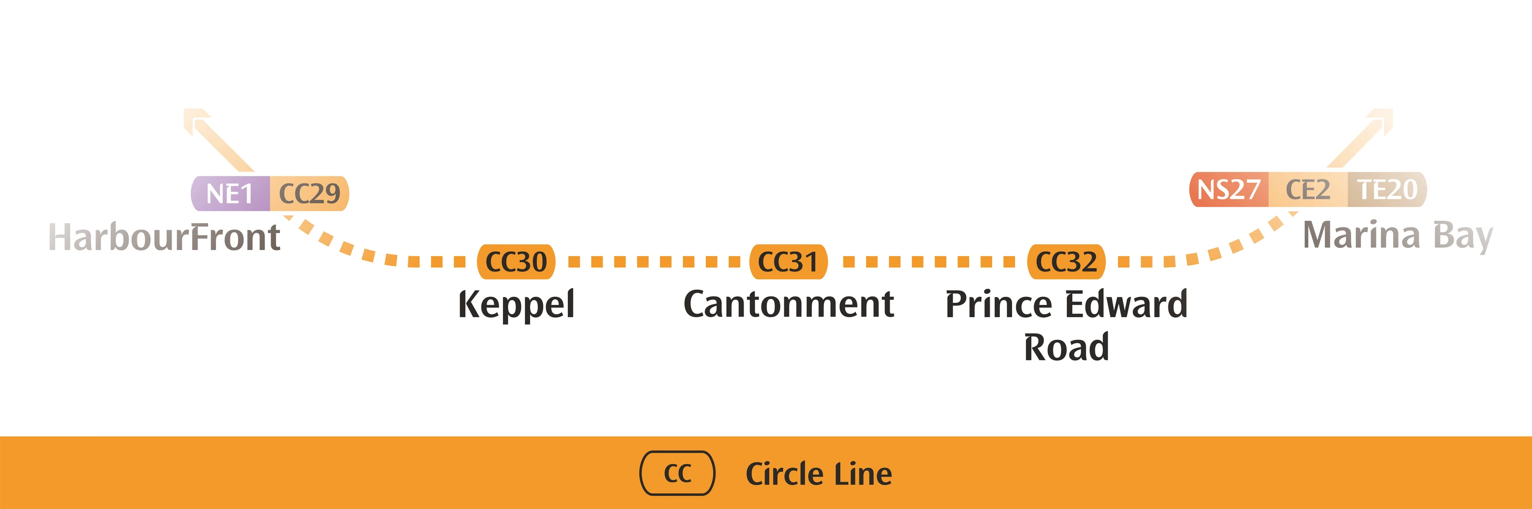
On 12 July 2026, Singapore's MRT network stops looking like a horseshoe. For seventeen years, since the Circle Line first opened in 2009, commuters travelling between HarbourFront and Marina Bay have had to detour — hopping onto the North-South Line or North East Line to bridge a gap that was never quite closed. Circle Line Stage 6 (CCL6) closes it. Three new stations — Keppel, Cantonment, and Prince Edward Road — slot into the missing arc, turning 33 stations and 12 interchange points into a genuine, unbroken 39km loop. If you live, work, or are shopping for property anywhere between Pasir Panjang and Paya Lebar, this is one of the more consequential pieces of transport infrastructure to land in Singapore this decade — and it comes with a free public preview on 4 July before the line opens properly a week later.
This isn't just a commuter convenience story, though. Rail lines move property scores. Distance-to-MRT is one of the single strongest predictors of a project's long-run desirability in Singapore's private residential market, and three brand-new stations opening simultaneously in the Keppel–Tanjong Pagar–Cantonment corridor is the kind of event that reshapes accessibility scoring for an entire pocket of the city almost overnight. This guide walks through what each station actually unlocks, who benefits immediately versus who's betting on the future, and how a data-driven scoring lens should think about the uplift.
The Loop, Closed: What CCL6 Actually Is
For context, the Circle Line was built in five stages between 2009 and its last extension, always as a horseshoe — CC1 Dhoby Ghaut around to CC29 HarbourFront, with the two ends never meeting. CCL6 is the sixth and final stage, and it's short in distance but outsized in impact: three stations bridging HarbourFront to Marina Bay (renumbered CC33, with Bayfront becoming CC34).
Key facts:
- Public preview: 4 July 2026, 9:30am–9:00pm (free access, no fare required)
- Full passenger service: 12 July 2026
- New stations: CC30 Keppel, CC31 Cantonment, CC32 Prince Edward Road
- Network result: A complete 39km loop, 33 stations, 12 interchanges to every existing line (North-South, East-West, North East, Downtown, Thomson-East Coast)
- Headline travel-time saving: LTA's own example — a Telok Blangah-to-Marina Bay trip that today requires transferring across multiple lines becomes a single-seat ride, saving roughly 10 minutes
The significance isn't only local. LTA frames the completed loop as strengthening connectivity between "western areas (Pasir Panjang, Kent Ridge), the Central Business District, and eastern zones (Paya Lebar, Mountbatten)" — in other words, this is a network-resilience upgrade, not just three new dots on a map. EdgeProp's property desk makes the same point from a different angle: the closed loop gives the Pasir Panjang stretch a direct, transfer-free ride into the CBD, tying the infrastructure directly to the long-running Greater Southern Waterfront (GSW) redevelopment story for the old port lands south of the city.
Station by Station: What Each Stop Actually Unlocks
Not all three stations are created equal. One sits in the middle of live, established residential and heritage catchments. Another is, for now, mostly surrounded by port infrastructure and represents a bet on the future rather than an immediate amenity upgrade. Here's the breakdown.
| Station | Code | Depth | Immediate catchment | Character |
|---|---|---|---|---|
| Keppel | CC30 | ~20m (shallowest) | PSA International, Keppel Distripark — port/logistics land | Future-facing: gateway to GSW redevelopment |
| Cantonment | CC31 | ~28m | Spottiswoode Park Estate, Everton Road cafe strip, Singapore Art Museum (Tanjong Pagar Distripark), Tanjong Pagar Railway Station | Richest immediate walking catchment — established residential + F&B + heritage |
| Prince Edward Road | CC32 | ~30m (deepest) | Shenton Way / Tanjong Pagar, Hock Teck See Temple | CBD-fringe, heritage-adjacent |
CC30 Keppel — the long game
Keppel station is the one to watch rather than the one to act on today. Surface-level, it's surrounded by PSA International port operations and Keppel Distripark — not exactly a neighbourhood with cafes and playgrounds. But that's precisely the point: planners have positioned it as the transit anchor for the Greater Southern Waterfront, the decades-long masterplan to convert former port land south of the CBD into a new residential and commercial district once port operations fully relocate to Tuas.
Worth being precise here: any current claims about exact unit counts or launch timelines for GSW housing near Keppel station aren't yet publicly confirmed in detail. Treat Keppel's property upside as prospective, not immediate — the station is opening years ahead of the neighbourhood it's ultimately built to serve.
CC31 Cantonment — the immediate winner
If you're looking for a station with a catchment that's already alive, Cantonment is it. It sits beneath the old Tanjong Pagar Railway Station — itself a conserved heritage building — and has four entrances serving:
- Spottiswoode Park Estate, an established residential enclave
- The Everton Road cafe and F&B strip, a well-known local dining pocket
- The Singapore Art Museum at Tanjong Pagar Distripark
- The historic Tanjong Pagar Railway Station building itself
This is the station where residents feel the change on day one, not in five or ten years. A neighbourhood that previously relied on a longer walk (or a bus leg) to HarbourFront or Tanjong Pagar MRT now gets a station on its doorstep with a direct, no-transfer run to Marina Bay.
CC32 Prince Edward Road — the CBD-fringe deep station
The deepest of the three at roughly 30 metres, Prince Edward Road serves the Shenton Way/Tanjong Pagar office and heritage cluster, including sites like the Hock Teck See Temple. It rounds out the trio by giving CBD-fringe workers and residents another entry point onto the loop.
Who Actually Benefits — And Who's Waiting
It's worth being disciplined about separating already-live uplift from speculative future uplift, because the three stations sit at very different points on that spectrum.
Immediate, tangible beneficiaries:
- Spottiswoode Park Estate residents — an established estate that gains a genuinely new, walkable MRT option via Cantonment station, not a future promise
- Tanjong Pagar/Everton Road area residents and tenants — shorter, transfer-free commutes to Marina Bay and the eastern CBD
- HarbourFront-adjacent estates — now sit on a fully closed loop rather than the end of a horseshoe branch, improving resilience (more route options if one line segment has disruptions) even where the direct distance to a station hasn't changed
Prospective, longer-horizon beneficiaries:
- Future Greater Southern Waterfront residents — Keppel station is infrastructure built ahead of the neighbourhood it will ultimately serve. The uplift here is a bet on GSW's build-out timeline, not a today-uplift
- Port-adjacent land generally — as PSA operations continue relocating to Tuas, land currently zoned for logistics becomes a redevelopment candidate, with Keppel MRT as its anchor amenity
A structural, network-wide beneficiary:
- Pasir Panjang and Kent Ridge estates, per EdgeProp's framing — these don't get a new station themselves, but the closed loop gives them a materially better path into the CBD than the pre-CCL6 horseshoe allowed, which is a subtler but real accessibility gain
CCL6: Immediacy of Property Impact by Area
(Impact scores above are illustrative of relative immediacy — established catchment vs. future-facing infrastructure — not a Hiva-computed metric.)
What to Watch Before You Read Too Much Into a Score
A few things worth being careful about, both as a resident reading this guide and as anyone using property scoring tools around this event:
- Don't assume a station connection that doesn't exist. Keppel and HarbourFront are two separate, non-interchange stations one stop apart on the loop — they do not directly connect to each other as an interchange. It's an easy mistake to make given the geographic proximity.
- Treat "future homes near Keppel" claims skeptically until sourced. Specific figures on unit counts for GSW housing near Keppel station are not yet confirmed in public planning materials at the level of detail some secondary sources imply — don't take a round number at face value without checking URA's own GSW masterplan documents.
- Scoring uplift isn't instant. Even once the line opens on 12 July, expect a lag before recomputed accessibility scores and district rankings reflect the new stations, tied to the pipeline's normal weekly/monthly recomputation cycle.
- Anticipation premiums are a claim to verify, not assume. It's intuitive that resale prices near Cantonment or HarbourFront might already reflect some "CCL6 anticipation" — but that requires checking actual transaction data (PSF trends over the past 12–24 months in the immediate catchment) rather than assuming it happened just because the story is plausible.
Food for Thought
- Transport access clearly matters to how a project scores — but how much of that should be forward-looking (rewarding an announced station before it opens) versus backward-looking (only counting a station once it's actually running)?
- Cantonment station serves an already-dense, already-desirable estate. Does a new MRT station add more value to a neighbourhood that's already strong, or to one that was previously underserved — and should scoring weight those two cases differently?
- Keppel station is essentially a bet on a redevelopment timeline that could run over years, possibly a decade or more. How should a scoring model handle "infrastructure that exists but the neighbourhood it's built for doesn't yet"?
- Now that the Circle Line is a genuine closed loop with 12 interchange points, does "distance to nearest MRT" still capture the full accessibility picture — or does network resilience (multiple route options, fewer single points of failure) deserve its own factor?
- With PSA's port operations gradually relocating to Tuas over the coming years, how should long-horizon buyers weigh a station like Keppel today against what the surrounding land is expected to become?